

NATIONAL GEOGRAPHIC APPALACHIAN TRAIL NJ, NY, CT, MA MAP PACK
NATIONAL GEOGRAPHIC
$28.99
(No reviews yet)

Write a Review
NATIONAL GEOGRAPHIC
NATIONAL GEOGRAPHIC APPALACHIAN TRAIL NJ, NY, CT, MA MAP PACK
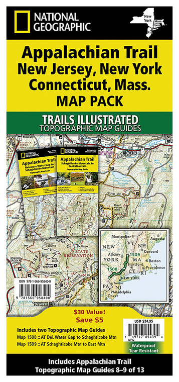
Navigating the northeastern United States' most iconic hiking corridor requires reliable, detailed cartography that goes beyond standard GPS devices. This comprehensive map pack covers four critical states along the Appalachian Trail—New Jersey, New York, Connecticut, and Massachusetts—providing hikers, backpackers, and outdoor enthusiasts with the precise terrain information needed to safely explore this legendary 2,190-mile footpath. Whether you're planning a multi-day thru-hike, section hiking expeditions, or day trips to iconic summits, this professionally designed reference tool combines expert geographic knowledge with practical trail navigation features.
- Four detailed topographic maps covering NJ, NY, CT, and MA sections of the Appalachian Trail with contour lines and elevation data
- National Geographic-quality cartography with proven accuracy and comprehensive terrain representation across northeastern landscapes
- Durable, water-resistant paper construction designed to withstand rain, sweat, and repeated field use without degradation
- Legend includes trail markers, water sources, shelter locations, road crossings, and points of interest along the route
- Printed at appropriate scale for hiking detail while remaining compact and packable for backpack travel
- Features magnetic declination lines and grid systems compatible with standard orienteering compasses
- Clear identification of natural features including ridgelines, valleys, forest coverage, and seasonal water sources
- Includes state boundary markings and town references for context and resupply planning
- Professional design emphasizes clarity and readability in outdoor conditions with high-contrast printing
These maps excel in real-world hiking scenarios where digital devices may fail due to dead batteries, signal loss, or hardware damage. Hikers appreciate the instant visual reference that paper maps provide, allowing quick terrain assessment without power consumption. The northeastern section of the Appalachian Trail presents complex topography with numerous ridgelines, stream crossings, and elevation changes—terrain that demands accurate, detailed cartography. The durable construction withstands the demands of multi-week backpacking trips, weather exposure, and constant referencing. Experienced trail users rely on these maps to identify alternative routes, locate water sources, and understand upcoming topography before embarking on each day's hike.
This map pack is essential for serious Appalachian Trail hikers, section hikers tackling the northeastern corridor, outdoor educators leading group expeditions, and map enthusiasts who value tangible geographic references. Whether you're a thru-hiker documenting your journey or a weekend adventurer exploring Connecticut's highlands or New York's ridge systems, these maps provide the geographic confidence needed for safe, informed trail navigation.
Questions about the NATIONAL GEOGRAPHIC APPALACHIAN TRAIL NJ, NY, CT, MA MAP PACK?
Reach out to our support team with any questions you might have!
Contact Us

