

NATIONAL GEOGRAPHIC APPALACHIAN TRAIL MAINE MAP PACK
NATIONAL GEOGRAPHIC
$28.99
(No reviews yet)

Write a Review
NATIONAL GEOGRAPHIC
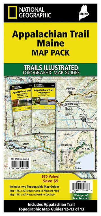
NATIONAL GEOGRAPHIC APPALACHIAN TRAIL MAINE MAP PACK
Planning a hiking adventure along one of America's most iconic long-distance trails? This comprehensive map pack delivers detailed topographic coverage specifically designed for the Maine section of the Appalachian Trail, ensuring you have reliable navigation tools for your backcountry journey. Whether you're a section hiker tackling portions of the trail or completing the entire Maine route, these professionally crafted maps provide the precision and durability needed for serious outdoor navigation in challenging terrain.
- Detailed topographic maps covering the complete Appalachian Trail route through Maine with contour lines and elevation data
- Water-resistant, tear-resistant paper construction designed to withstand rain, humidity, and rigorous field conditions
- Large-scale format ensuring trail features, water sources, and terrain details remain clearly legible without excessive folding
- Marked trail intersections, shelter locations, and water access points essential for trip planning and emergency preparedness
- Includes comprehensive legend explaining topographic symbols, elevation profiles, and map grid references
- Lightweight, compact design easily fits in backpack pockets or map cases for convenient on-trail reference
- Produced by trusted cartography experts with intimate knowledge of Appalachian terrain and trail conditions
- Scaled appropriately to balance overview context with local detail around critical trail sections and elevation changes
These maps excel in real-world hiking scenarios where electronic devices may fail, battery power runs out, or cellular coverage disappears entirely. Hikers routinely praise the accuracy of trail routing, the clarity of natural and man-made landmarks, and the precision of water source locations—critical information when planning water breaks and campsite selection on multi-day expeditions. The durable paper construction withstands constant handling, compression in backpacks, and exposure to morning dew and afternoon downpours without degrading readability. Whether you're navigating the famous Baxter State Park section, the rugged terrain around Monson, or any intermediate segments, these maps serve as your most reliable navigation partner when combined with a compass and basic orienteering skills.
This map pack is ideal for experienced backcountry hikers, Appalachian Trail through-hikers, section hikers planning extended trips, outdoor guides leading group expeditions, and anyone seeking authoritative paper-based navigation for Maine's most challenging hiking terrain. Serious adventurers trust these maps as essential safety equipment alongside proper gear and preparation.
Questions about the NATIONAL GEOGRAPHIC APPALACHIAN TRAIL MAINE MAP PACK?
Reach out to our support team with any questions you might have!
Contact Us

