

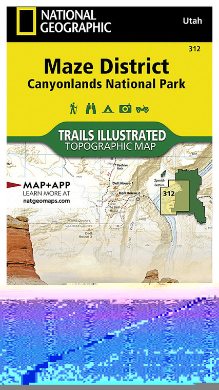
NATIONAL GEOGRAPHIC MAZE DISTRICT CANYONLANDS NATIONAL PARK MAP
NATIONAL GEOGRAPHIC
$13.99
(No reviews yet)

Write a Review
NATIONAL GEOGRAPHIC
NATIONAL GEOGRAPHIC MAZE DISTRICT CANYONLANDS NATIONAL PARK MAP
Exploring the rugged terrain of Canyonlands National Park demands a reliable navigation tool that captures every canyon, mesa, and hidden trail in stunning detail. This detailed topographic map of the Maze District combines National Geographic's cartographic expertise with practical outdoor utility, making it an essential companion for hikers, backpackers, and adventure enthusiasts planning trips through one of Utah's most challenging and rewarding wilderness areas. Whether you're navigating slot canyons, planning multi-day backcountry expeditions, or simply studying the landscape before your visit, this map provides the geographic intelligence you need for safe, confident exploration.
- Detailed topographic contours showing elevation changes, canyon depths, and terrain relief for precise route planning and navigation
- Comprehensive trail markings including established routes, water sources, camping areas, and backcountry access points throughout the Maze
- National Geographic's signature cartographic accuracy with current geographic data and named landmarks for reliable field reference
- Durable, water-resistant paper construction designed to withstand backcountry conditions, moisture, and repeated folding
- Clear color coding distinguishes between different terrain types, vegetation zones, and administrative boundaries within the park
- UTM grid overlay and latitude/longitude coordinates for GPS integration and precise waypoint marking
- Inset maps showing regional context, nearby attractions, and access routes from nearby towns and highways
- Printed at optimal scale to balance comprehensive coverage with detailed local features essential for wilderness navigation
The Maze District represents some of the most remote and intricate canyon country in North America, where navigation challenges and reward stunning isolation. This map excels in real-world backcountry scenarios, whether you're locating reliable water sources in seasonal conditions, identifying alternate routes around obstacles, or understanding the vertical relationships between overlooks and canyon floors. Experienced hikers appreciate National Geographic maps for their reliability under field conditions—the paper quality resists tearing even when wet, and the print quality remains legible even after months in a backpack. The topographic representation helps prevent navigation surprises by clearly showing which canyons are passable, where terrain steepens dramatically, and how water flow patterns affect seasonal access.
This map is ideal for serious backcountry explorers, wilderness photographers, geology enthusiasts, and adventure planners who demand accuracy and durability in remote terrain. Whether you're preparing for a challenging multi-day expedition into the Maze's heart or simply want to understand the landscape's complex geography before visiting, this professionally crafted reference deserves a spot in your outdoor library and backpack.
Questions about the NATIONAL GEOGRAPHIC MAZE DISTRICT CANYONLANDS NATIONAL PARK MAP?
Reach out to our support team with any questions you might have!
Contact UsRelated Products
-
-
NATIONAL GEOGRAPHIC ISLAND IN THE SKY DISTRICT: CANYONLANDS NATIONAL PARK MAP
$13.99NATIONAL GEOGRAPHIC
-
-


