![NATIONAL GEOGRAPHIC WIND RIVER RANGE NORTH MAP [PINEDALE, DUBOIS]](https://cdn11.bigcommerce.com/s-fbirgufogo/images/stencil/300x300/products/83810/108857/369688__52448.1775170213.jpg?c=1 "NATIONAL GEOGRAPHIC WIND RIVER RANGE NORTH MAP [PINEDALE, DUBOIS]")
![NATIONAL GEOGRAPHIC WIND RIVER RANGE SOUTH MAP [LANDER, CIRQUE OF THE TOWERS]](https://cdn11.bigcommerce.com/s-fbirgufogo/images/stencil/1280x1280/products/83824/108874/667054__38473.1775170220.jpg?c=1 "NATIONAL GEOGRAPHIC WIND RIVER RANGE SOUTH MAP [LANDER, CIRQUE OF THE TOWERS]")
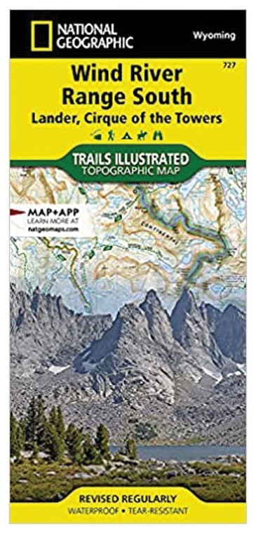
NATIONAL GEOGRAPHIC WIND RIVER RANGE SOUTH MAP [LANDER, CIRQUE OF THE TOWERS]
NATIONAL GEOGRAPHIC
$16.99
(No reviews yet)

Write a Review
NATIONAL GEOGRAPHIC
NATIONAL GEOGRAPHIC WIND RIVER RANGE SOUTH MAP [LANDER, CIRQUE OF THE TOWERS]
Navigating remote alpine terrain demands precision, durability, and reliable cartography—especially in challenging mountain environments where GPS signals fade and conditions shift rapidly. This detailed topographic map covers the Wind River Range South, including the legendary Lander area and the iconic Cirque of the Towers, making it an essential navigation tool for backcountry hikers, mountaineers, backpackers, and wilderness explorers. Whether you're planning a multi-day expedition, scouting climbing routes, or simply want to understand the terrain before venturing into one of North America's most pristine mountain ranges, this map provides the geographic intelligence you need to navigate safely and confidently.
- Large-scale topographic detail with 80-meter contour intervals revealing subtle terrain features and elevation changes
- Durable waterproof paper construction withstands rain, snow, sweat, and rough handling during extended backcountry use
- Vibrant color coding distinguishes elevation zones, water features, vegetation, and established trail networks at a glance
- Comprehensive trail markings, waypoints, and landmark annotations guide navigation through complex alpine terrain
- Clearly labeled peaks, passes, lakes, and geographic features across the Wind River Range South region
- Includes detailed inset coverage of the renowned Cirque of the Towers climbing area with technical route information
- National Geographic expertise and cartographic standards ensure accuracy and reliability in remote wilderness settings
- Compact fold format fits standard map cases and backpack pockets without bulk or excessive weight
- Ideal complement to GPS devices, providing visual context and backup navigation when electronic systems fail
In the field, this map excels where technology falters. The Wind River Range presents serious navigation challenges—dense terrain, variable weather, and countless interconnected valleys create genuine exposure for unprepared travelers. The Cirque of the Towers section deserves particular attention: this concentrated area of granite peaks, turquoise lakes, and technical scrambles demands precise route-finding that only detailed cartography can provide. Experienced mountaineers use this map for approach planning, camp selection, and understanding rock formation patterns that influence climbing strategy. Backcountry skiers rely on its contour precision to evaluate slope angles and avalanche terrain. Wildlife photographers and naturalists study it to locate remote water sources and identify likely animal corridors.
This map is purpose-built for serious wilderness users who respect the mountains and plan accordingly. Pack it alongside a compass and altimeter for complete navigational independence, or carry it as essential backup to modern GPS systems. Whether you're a first-time backpacker exploring accessible trails or an accomplished mountaineer tackling technical objectives in the Cirque, this map delivers the geographic foundation required for safe, successful wilderness travel in Wyoming's crown jewel mountain range.
Questions about the NATIONAL GEOGRAPHIC WIND RIVER RANGE SOUTH MAP [LANDER, CIRQUE OF THE TOWERS]?
Reach out to our support team with any questions you might have!
Contact Us

