

NATIONAL GEOGRAPHIC PCT CA NORTH MAP PACK
NATIONAL GEOGRAPHIC
$28.99
(No reviews yet)

Write a Review
NATIONAL GEOGRAPHIC
NATIONAL GEOGRAPHIC PCT CA NORTH MAP PACK
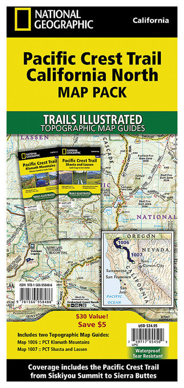
Navigating the Pacific Crest Trail through California's northern wilderness demands reliable, detailed cartography that goes beyond basic GPS data. This comprehensive map pack delivers professional-grade topographic coverage specifically designed for the PCT's California northbound section, combining the trusted expertise of National Geographic with the practical needs of long-distance hikers, backpackers, and trail enthusiasts. Whether you're planning a multi-week thru-hike or tackling regional sections of this iconic 2,650-mile route, this map pack provides the essential navigation tools to safely traverse some of the most remote and challenging terrain in North America.
- Detailed topographic maps covering the entire Pacific Crest Trail route through northern California with contour intervals and elevation data
- Waterproof, tear-resistant paper construction withstands rain, river crossings, and extended backcountry exposure
- Includes water source locations, established campsites, and resupply points crucial for multi-day wilderness journeys
- Multiple map sheets with overlapping coverage zones eliminate navigation gaps between sections
- Clear terrain representation showing ridge lines, valleys, passes, and geological features for route planning
- Printed at optimal scale for detailed planning while remaining packable in standard backpack storage
- National Geographic's cartographic accuracy derived from USGS data and field-verified trail information
- Includes supplementary information on permits, regulations, and seasonal considerations for California hiking
- Compatible with standard map cases and protective sleeves for extended trail use
Real-world performance on the trail demonstrates why this map pack has become standard equipment for PCT hikers. The waterproof paper maintains legibility even when wet from morning condensation or unexpected weather, while the durable construction survives repeated folding and unfolding at camp and trailside decision points. Hikers consistently report that the detailed topography accurately represents actual terrain, helping predict water availability, identify shortcuts, and plan mileage with confidence. The marked water sources and camping areas provide critical safety information for route planning, allowing users to identify resupply opportunities and establish realistic daily targets based on reliable terrain information rather than guesswork.
This map pack serves experienced backpackers, PCT thru-hikers, section hikers, and weekend adventurers seeking comprehensive navigation coverage for California's northern wilderness sections. It's equally valuable for trip planners preparing detailed itineraries months in advance and for active hikers who prefer paper maps as backup to electronic navigation tools. Anyone tackling substantial distances on the Pacific Crest Trail will appreciate having detailed, battle-tested cartography in their pack.
Questions about the NATIONAL GEOGRAPHIC PCT CA NORTH MAP PACK?
Reach out to our support team with any questions you might have!
Contact Us

